In the fast-moving world of surveying, picking the right GNSS DGPS device isn't just a matter of preference – it’s super important if you want your measurements to be spot-on and trustworthy. According to a report from the International GNSS Service (IGS), using GNSS tech in surveying has really made a difference — errors have dropped significantly, boosting accuracy by up to 30% compared to older, more traditional methods. More surveyors are leaning on GNSS DGPS systems these days, but it’s crucial to really understand what features and functions make these instruments suitable for different jobs.
Dr. Robert Johnson, who’s pretty much an expert in GNSS tech, points out that choosing the right instrument isn’t just about specs — it’s about how well it fits the specific task you’re tackling. He adds, “The real effectiveness comes down to how well these devices meet your needs in the field.” So, when selecting your equipment, think about accuracy, how user-friendly it is, and how tough it is to handle in challenging environments. As the push for high-precision geospatial data keeps growing in many industries, knowing the ins and outs of GNSS DGPS tools really becomes a must if you want to get the best results for your projects.

Understanding GNSS and DGPS: Key Concepts and Differences
Global Navigation Satellite System (GNSS) technology has revolutionized the way surveys are performed across various fields, from construction to agriculture. GNSS utilizes a network of satellites to provide accurate positioning information anywhere on Earth. However, while GNSS can deliver location data, Differential Global Positioning System (DGPS) enhances this accuracy by correcting the signals using ground-based reference stations. This dual approach significantly reduces positioning errors, which can range from several meters down to a few centimeters, thus improving the quality of measurements in surveying.
Understanding the core differences between GNSS and DGPS is crucial for choosing the right survey instrument. While GNSS alone may achieve an accuracy of 5 to 10 meters, the integration of DGPS can push this level of precision to within 1 to 2 centimeters. According to industry reports, utilizing DGPS for topographic mapping can ensure reliability in data collection and analysis, yielding a 98% confidence level in measurements compared to GNSS alone, which typically falls short in precision-sensitive tasks.
Tips: When selecting a DGPS survey instrument, examine the compatibility with various GNSS constellations and ensure that it can process corrections from multiple reference stations for enhanced accuracy. Additionally, bear in mind the environmental factors affecting signal quality, such as foliage or building obstructions, as they can influence measurement reliability.
Identifying Your Surveying Needs: Factors to Consider
When selecting the right Gnss Dgps Survey Instrument for precise measurements, it's essential to first identify your specific surveying needs. Consider the nature of the projects you will be undertaking. Are you focusing on land surveying, marine navigation, or construction? Each of these areas may require different instrument capabilities and configurations. For example, if your work involves small lot surveying in urban areas, you might need a more portable and user-friendly device with high accuracy in confined spaces. Conversely, large-scale applications like agricultural or forestry surveys may warrant advanced systems capable of covering expansive areas.
Additionally, take into account your accuracy requirements and environmental conditions. The level of accuracy you need will significantly influence your choice of equipment, as some instruments provide measurements with millimeter precision, while others might suffice with centimeter-level accuracy. Reflect on the environments in which you'll be operating—will you be in open fields, dense forests, or urban settings? Each scenario poses unique challenges regarding signal reception and multipath effects. Also, consider factors such as battery life, user interface, and the availability of support and training. By thoroughly assessing these aspects, you can better select a GNSS DGPS survey instrument that aligns with your specific needs and enhances the quality of your measurements.
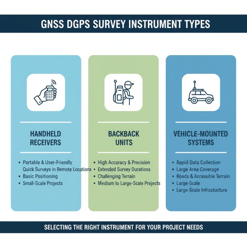
Types of GNSS DGPS Survey Instruments Available
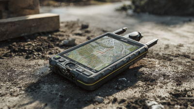
When selecting the appropriate GNSS DGPS survey instrument, it is essential to understand the various types available in the market. The most common types include handheld receivers, backpack units, and vehicle-mounted systems. Handheld receivers are portable and user-friendly, making them ideal for quick surveys in remote locations. These instruments typically offer basic positioning capabilities, suitable for small-scale projects.
Backpack units provide a balance of accuracy and mobility, allowing surveyors to carry out extensive surveys while on foot. These systems are often equipped with advanced features, such as real-time differential corrections and enhanced signal processing, which can significantly improve measurement precision. They are particularly useful in urban areas or other challenging environments where signal obstructions can impact accuracy.
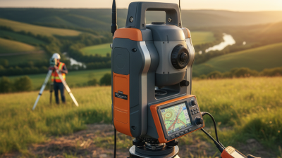
For larger scale projects, vehicle-mounted systems are often employed. These instruments are designed to deliver high-accuracy measurements over vast areas and can be integrated with mapping software for seamless data collection and processing. Vehicle-mounted units are typically utilized in infrastructure projects, land surveying, and environmental monitoring, where high accuracy is paramount. By understanding the strengths and applications of these different GNSS DGPS survey instruments, users can make informed decisions to ensure precise measurements for their specific surveying needs.
Evaluating Instrument Accuracy: Specifications to Look For
When selecting a GNSS DGPS survey instrument, evaluating instrument accuracy is paramount. One of the primary specifications to consider is the system’s positional accuracy, which is often denoted in centimeters or meters. High-precision units provide better accuracy, which is crucial for applications demanding tight tolerances, such as land surveying or construction projects. Additionally, look for specifications regarding the horizontal and vertical accuracy as they can differ significantly depending on the receiver's specifications and the environmental conditions during data collection.
Another essential aspect to consider is the satellite constellation and signal processing capabilities of the instrument. The number of satellites that the receiver can access directly affects accuracy; more satellites generally lead to more robust positioning solutions. Moreover, advanced signal processing techniques, such as dual-frequency operation, can mitigate errors caused by atmospheric conditions and multipath effects, enhancing the overall measurement reliability. Understanding these specifications will help ensure that the chosen instrument meets the accuracy requirements of your surveying needs.
Budget Considerations: Cost vs. Performance
When selecting a GNSS DGPS survey instrument, it is crucial to consider not only the initial cost but also the long-term performance and accuracy it provides. According to a recent industry report by the International Association of Geodesy, investing in high-quality DGPS equipment can yield a significant return on investment due to reduced data correction time and improved measurement accuracy. Instruments that fall below $5,000 often compromise on precision and may result in data that necessitates expensive post-processing corrections, ultimately inflating project costs.
**Tips:** Before making a purchase, evaluate your project's specific measurement needs and consider whether the increased capabilities of higher-end instruments justifies their cost. While budget-friendly options are appealing, they may lead to operational inefficiencies and inaccuracies. A mid-range instrument that offers reliable performance could be the best choice for many surveying projects.
Furthermore, consider the total cost of ownership, which includes maintenance, training, and software requirements. A 2022 survey by the Geospatial World Network showed that agencies allocating 15% of their budget to training and support saw up to a 25% increase in operational efficiency. The choice of a GNSS DGPS survey instrument shouldn't focus solely on the purchase price; instead, it should reflect a balance between upfront cost and long-term functionality to ensure successful project outcomes.
How to Choose the Right GNSS DGPS Survey Instrument for Accurate Measurements - Budget Considerations: Cost vs. Performance
| Model | Price Range (USD) | Accuracy (cm) | Measurement Frequency (Hz) | Battery Life (hours) | Weight (kg) |
| Model A | $2,000 - $3,000 | 2 | 5 | 10 | 1.5 |
| Model B | $1,500 - $2,500 | 5 | 10 | 12 | 1.2 |
| Model C | $3,000 - $4,500 | 1.5 | 2 | 8 | 2.0 |
| Model D | $2,500 - $3,500 | 3 | 8 | 11 | 1.8 |
Assessing Usability and Portability of Survey Instruments
When selecting a GNSS DGPS survey instrument, usability and portability are critical factors to consider. Surveying often requires professionals to work in diverse and sometimes challenging environments. Thus, an instrument should be user-friendly, with an intuitive interface that allows for quick learning curves, minimizing training requirements. Controls should be easily accessible, and the display should offer clear visibility, even in bright sunlight or low-light conditions. Moreover, the ability to customize settings can enhance usability, allowing users to configure the instrument according to their specific project needs.
Portability is equally essential, as surveyors frequently move from one location to another. A lightweight and compact design makes transportation simpler, reducing fatigue during long working hours. Additionally, rugged construction that ensures durability in various weather conditions can enhance the practicality of the instrument. Look for features such as integrated battery solutions for extended operation time and compatibility with mobile devices, enabling seamless data transfer and remote monitoring. Ultimately, a combination of usability and portability in a GNSS DGPS survey instrument can greatly improve efficiency and accuracy in measurement tasks.
Support and Service: Importance of After-Sales Assistance
In the realm of GNSS and DGPS surveying, the importance of after-sales assistance cannot be overstated. A reliable support system significantly enhances the usability of advanced surveying instruments, ensuring that operators can maximize their efficiency and accuracy. According to a recent industry report from the International GNSS Service, nearly 30% of surveying professionals cited a lack of tech support as a key factor in unsuccessful project outcomes. This emphasizes the need for manufacturers to offer robust after-sales support to facilitate quick resolution of issues, training on new technologies, and regular maintenance check-ups.
When choosing a GNSS DGPS survey instrument, it’s essential to consider the level of after-sales service offered. Effective support can include software updates, access to a customer service hotline, and user training sessions. A study by Geospatial World indicated that companies with a strong commitment to service support experienced a 40% increase in customer satisfaction, leading to repeat business and referrals. This highlights the correlation between after-sales assistance and long-term success in the surveying industry.
**Tips:**
1. Before purchasing, inquire about the availability of training programs and technical support, as these can greatly reduce downtime.
2. Consider instruments that offer comprehensive warranty services and easy access to spare parts to ensure that your equipment remains operational with minimal interruption.
3. Read customer reviews focusing on support experiences to gauge the reliability of after-sales service from different providers, as firsthand accounts can be invaluable in making an informed decision.
Comparison of GNSS DGPS Survey Instrument Accuracy
This chart displays the accuracy of various GNSS DGPS survey instruments. Choosing the right instrument is crucial for achieving precise measurements, as demonstrated by the varying accuracy levels shown above.
Comprehensive Guide to New Leica GPR121 Equivalent Total Station Monitor Prism Assembly and Its Applications in Surveying
The new total station monitor prism assembly, designed with precision and functionality in mind, serves as an essential tool in modern surveying applications. Featuring a high-quality circular prism equipped with an anti-reflex coating, this assembly achieves impressive range capabilities of up to 3,500 meters (11,500 feet). The removable GPR121 target plate enhances versatility, allowing for easy adjustments and maintenance, which are crucial during extensive fieldwork.
One of the key advantages of this prism assembly lies in its centering accuracy of just 1.0 mm. This level of precision ensures reliable measurements, facilitating more accurate data collection in various surveying tasks, from land surveying to construction projects. The durability offered by the metal holder further enhances the assembly's performance, making it a dependable choice for professionals who rely on accurate Surveying Equipment to deliver the best results in their projects.
The robust design and advanced features of this total station monitor prism not only improve workflow efficiency but also contribute to the overall quality of data obtained in challenging environments. Surveyors and engineers can leverage this technology to meet the increasing demands for precision in their work, ultimately achieving enhanced project outcomes.
FAQS
: You should consider the nature of your projects (land surveying, marine navigation, or construction), your accuracy requirements, environmental conditions, battery life, user interface, and the availability of support and training.
Different projects may require different capabilities; for example, small lot surveying in urban areas may need a more portable device, while large-scale applications might require advanced systems for expansive areas.
Look for positional accuracy, horizontal and vertical accuracy, the number of satellites accessible, and signal processing capabilities such as dual-frequency operation to mitigate errors.
Environmental conditions impact signal reception and accuracy; factors such as open fields, dense forests, or urban settings can affect the performance of the instrument.
A user-friendly interface minimizes training requirements and allows for quick adjustments during use, enhancing overall efficiency in measurement tasks.
Portability makes it easier for surveyors to move between locations, reducing fatigue and improving the practicality of using the instrument in diverse environments.
Look for intuitive controls, clear display visibility in varying lighting conditions, customizable settings, and features that enhance accessibility for improved user experience.
Extended battery life is crucial for long working hours and reduces downtime, enabling continuous operation during surveying tasks.
Rugged construction enhances durability in various weather conditions, ensuring the instrument can withstand the challenges of outdoor surveying work.
Access to more satellites generally leads to improved positioning solutions, enhancing accuracy and reliability during data collection.
Conclusion
When selecting a GNSS DGPS survey instrument for precise measurements, it is essential to understand the fundamental concepts of GNSS (Global Navigation Satellite System) and DGPS (Differential GNSS), as well as their distinctions. Identifying specific surveying needs, such as project scale and environment, can significantly influence the choice of instrument. A variety of GNSS DGPS survey instruments are available, each catering to different requirements, and it’s crucial to evaluate their accuracy by examining key specifications.
Additionally, budget considerations play a vital role in balancing cost and performance. The usability and portability of the instruments should also be assessed to ensure ease of operation in various field conditions. Lastly, reliable support and service are paramount; after-sales assistance can greatly enhance the experience and success of using the GNSS DGPS survey instrument for accurate measurements.